

Executive Overview
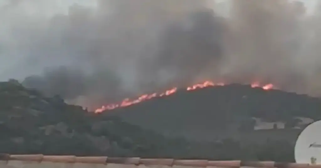
A ferocious and fast-moving wildfire erupted on the French island of Corsica on Thursday afternoon, August 27, carving a path of destruction through the rugged hillsides near the commune of Calenzana in the Haute-Corse region. Driven by intense, bone-dry south winds, the blaze materialized swiftly at approximately 3:20 p.m. local time (2:20 p.m. BST), catching residents and holidaymakers off guard.
Within hours, the wildfire devoured between 30 and 40 hectares of dry brush and forested land, leaping over ridges with terrifying momentum. Local emergency services, alongside specialized forest fire protection agencies, mounted a massive, coordinated response. Nearly 200 firefighters, supported by a formidable fleet of aerial firefighting assets including Canadair water bombers, a Dash-8 aircraft, and a water-bombing helicopter, have been deployed to combat the raging inferno.
The rapid spread of the fire has directly threatened human life, residential properties, and local infrastructure. Fire Commander Frédéric-Antoine Santoni confirmed that at least seven structures—ranging from permanent homes and rustic sheds to mobile homes—have sustained varying degrees of damage. Residents in the path of the flames were forced into urgent evacuations, leaving behind personal belongings as thick, billowing clouds of black smoke darkened the Corsican sky.
The incident has sent shockwaves through the local community and raised acute concerns for the thousands of international tourists, including many British nationals, currently frequenting the island during the peak summer holiday season. As ground crews battle punishing terrain and relentless winds into the evening, local authorities continue to urge the public to avoid the affected sectors to facilitate emergency access.
Detailed Chronology of the Disaster
3:20 PM – 3:40 PM: The Sudden Outbreak and Rapid Acceleration
The emergency began unfolding in the mid-afternoon hours of August 27. Near the commune of Calenzana, an ignition point quickly escalated into an uncontrolled wildfire. According to Fire Commander Frédéric-Antoine Santoni, the fire’s aggression from the outset was fueled by an unusually intense and parched south wind sweeping across the Haute-Corse landscape.
The meteorological conditions created a tinderbox environment. Witnesses reported that the flames did not merely crawl along the undergrowth; instead, driven by powerful gusts, fire spotting and towering flame fronts leapt up to 300 meters at a time, allowing the fire to bypass natural firebreaks and sprint across the hillside terrain.
3:40 PM – 4:30 PM: Immediate Evacuations and Local Panic
As the smoke plume grew thick and visible from miles away—even drawing the gaze of beachgoers along the coast—residents living between Montegrosso and Calenzana realized they were directly in the path of the blaze.
Anne, a 69-year-old local resident, recounted the harrowing moments of her evacuation to regional outlet Corse Matin. "The children were in the pool when we saw thick black smoke," she said. "A friend came to tell us we had to leave. We put the gas cylinders in the pool and jumped in the car. We don’t know where to go while we wait. I hope everything will be alright."
Emergency services moved quickly to secure the perimeter, assisting vulnerable citizens and issuing immediate evacuation orders for homes situated in the direct line of fire. The Fire and Rescue Service of the Haute-Corse region (SIS 2B) issued urgent status updates, emphasizing that human life and property protection remained the absolute priorities.
4:30 PM – 6:00 PM: Deployment of Aerial Support and Ground Reinforcements
Recognizing that ground crews alone could not stem the tide of the fast-moving flames in the difficult terrain, regional authorities escalated the response. By late afternoon, more than 170 to 200 professional and volunteer firefighters were actively engaged on the ground.
Simultaneously, the aerial firefighting division swung into action. Two Canadair amphibious aircraft, one Dash-8 turboprop airtanker, and a dedicated water-bombing helicopter arrived overhead. These aircraft began executing precision drops of water and fire retardant directly onto the roaring fire front. Videos shared online by the Forest Fire Prevention and Reporting Association (PSFDF) captured the dramatic sights and sounds of the airtankers skimming low over the hillsides, releasing torrents of water to suppress the ferocious heat.
Supporting Context & Metrics
Geographical and Environmental Vulnerability
Corsica, known for its breathtaking landscapes, rugged mountains, and deep historical charm, is a prime destination for European travelers. However, its Mediterranean climate also makes it acutely susceptible to extreme wildfire risks during the summer months.

The Haute-Corse region, characterized by dense maquis shrubland, dry pine forests, and steep topographical gradients, acts as an ecological amplifier for fires. Prolonged summer heatwaves dry out vegetation to critical levels, transforming the landscape into a volatile fuel source. When combined with seasonal high winds—such as the south winds reported during the Calenzana incident—even a small spark can explode into a major catastrophe within minutes.
Quantifying the Crisis: Key Figures
- Area Burned: Provisional estimates place the destroyed landmass between 30 and 40 hectares (approximately 74 to 99 acres).
- Personnel Deployed: Approximately 170 to 200 firefighters operating on the ground.
- Aerial Assets: 2 Canadair water-bombing planes, 1 Dash-8 airtanker, and 1 water-bombing helicopter.
- Structural Damage: At least 7 structures impacted, including residential homes, storage sheds, and mobile homes.
- Evacuated Populations: Dozens of residents displaced from properties between Montegrosso and Calenzana.
Official Statements and Emergency Responses
The emergency response has involved multi-agency coordination between local civil protection units, regional government officials, and specialized forestry associations.
The Fire and Rescue Service of Haute-Corse (SIS 2B) released an official operational briefing stating:
"Operations are continuing to contain the fire’s progression, protect homes and secure exposed people and property. We are facing a fire that spread very quickly, driven by an intense and very dry south wind."
Elaborating on the tactical challenges at the site, Fire Commander Frédéric-Antoine Santoni provided direct commentary to the press:
"The flames were leaping 300 meters. The provisional burned area is 30 to 40 hectares. Houses, sheds, and mobile homes have been affected. Our primary objective remains safeguarding lives and preventing further structural incursions as the wind shifts."
The Forest Fire Prevention and Reporting Association (PSFDF) utilized digital platforms, notably X (formerly Twitter), to broadcast real-time warnings, video footage, and safety advisories. Their public appeals reiterated strict community guidelines:
"Avoid the sector. Facilitate access for emergency and rescue vehicles. Do not interfere with ongoing water drops or ground transit."
Future Outlook & Ongoing Risks
As night falls over the Haute-Corse landscape, the immediate battle transitions from aggressive daytime suppression to nocturnal containment and mop-up operations. While the deployment of high-capacity aircraft like the Canadair and Dash-8 units has proven vital in checking the forward momentum of the primary fire front during daylight hours, air operations are heavily restricted or halted entirely after dark.
This leaves the containment effort entirely in the hands of ground crews. Firefighters must now navigate treacherous, uneven terrain under reduced visibility, painstakingly extinguishing hot spots, dousing lingering embers, and protecting perimeter zones around vulnerable residential enclaves.
Meteorological forecasts for the region will dictate the operational challenges of the coming days. Sustained high temperatures, low humidity, and unpredictable wind shifts remain major concerns for emergency commanders. If winds remain calm overnight, crews stand a strong chance of establishing a secure perimeter. However, any resurgence in wind speed risks reigniting dormant pockets of fuel within the 40-hectare burn scar.
For the residents of Calenzana and Montegrosso, the immediate future is filled with uncertainty. Displaced families await clearance from civil protection authorities before they can safely return to assess property damage or inspect homes saved by the narrow margins of firefighting intervention. Meanwhile, regional authorities are expected to launch a formal investigation into the ignition source of the blaze once the emergency phase has fully subsided, casting a renewed spotlight on the escalating threat of climate-driven wildfires across the Mediterranean basin.