

Executive Overview
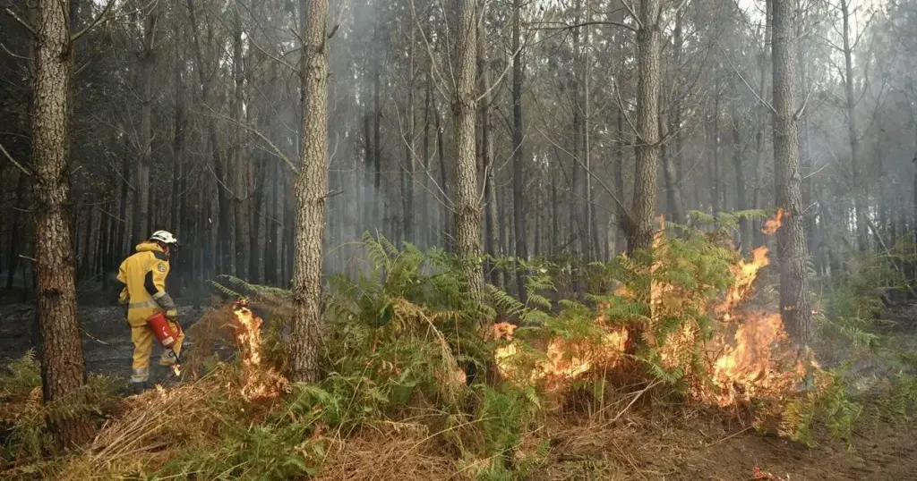
What began as a localized environmental emergency in eastern Belgium has rapidly escalated into a profound international crisis. The High Fens (Hautes Fagnes) nature reserve—a pristine and ecologically sensitive upland plateau—is currently being ravaged by what authorities have officially confirmed as the largest wildfire in Belgian history.
Over the past 24 hours, the inferno has aggressively doubled in size, scorching an estimated 3,000 hectares (approximately 7,500 acres) of dense brush, peatlands, and forest. Fueled by severe drought conditions, high temperatures, and shifting winds, the flames have officially breached international boundaries. On Sunday, the crisis crossed from the Belgian province of Liège into Germany, triggering urgent evacuation orders for residents in the North Rhine-Westphalian historic town of Monschau.
The emergency response has evolved into a massive, multi-national undertaking. Firefighters, civil protection agencies, and specialized aerial units from Belgium, Germany, Luxembourg, and the broader European Union civil protection mechanism are working in tandem under exceptionally hazardous conditions. Despite the deployment of more than 250 frontline personnel operating around the clock, authorities warn that the situation remains deeply volatile and "challenging," with containment lines constantly threatened by unpredictable weather patterns.
Detailed Chronology: How the Disaster Unfolded
The Ignition and Initial Spread (Mid-Week to Friday)
The disaster originated deep within the High Fens national park in eastern Belgium. While the definitive root cause remains under active investigation by regional environmental police, experts note that the landscape was already tinder-dry following weeks of unusually sparse rainfall and persistent summer heatwaves.
By Friday, the fire had broken containment lines, feeding rapidly on the region’s rich peat layers and coniferous overgrowth. High winds whipped embers across the undulating terrain, transforming small spot fires into an uncontrollable wall of flame. Local fire brigades in the Liège province were immediately overwhelmed by the scale and velocity of the blaze, prompting urgent calls for regional and federal reinforcements.
Escalation and the Cross-Border Spillover (Saturday)
By Saturday, the inferno’s footprint had exploded, expanding exponentially over a 24-hour window to engulf roughly 3,000 hectares of protected land. Thick, toxic plumes of smoke drifted across the international border, enveloping nearby communities in a dense, hazardous haze.
As night fell on Saturday, the crisis took a dramatic cross-border turn. The flames crept perilously close to the German frontier, pushing municipal authorities in the historic German town of Monschau—situated in the North Rhine-Westphalian region—to take pre-emptive defensive measures. Recognizing the imminent danger posed by shifting wind directions, the town administration issued mandatory evacuation directives for specific outlying districts, most notably Kalterherberg, focusing on vulnerable zones such as Ruitzhof and Geisberg.
Current Operations and Evacuations (Sunday)
As of Sunday evening, emergency procedures are running at peak intensity. In Belgium, approximately 600 residents living close to the border in the Liège region were ordered to evacuate their homes over the weekend as air quality plummeted to hazardous levels.
Across the border in Germany, while the initial evacuation order directly impacted a localized cluster of 17 homes affecting up to 30 people in Kalterherberg, local civil defense coordinators remain on high alert. An emergency shelter has been swiftly established at a high school in the nearby town of Simmerath, located roughly five miles away, to accommodate displaced citizens and provide psychological, medical, and logistical support.
Supporting Context & Metrics: Understanding the Scale
To fully comprehend the gravity of the High Fens wildfire, one must analyze the unique topography, climate vulnerabilities, and logistical hurdles facing the coalition of emergency responders.
The Vulnerability of the High Fens
The High Fens (Hautes Fagnes) is a unique upland plateau spanning eastern Belgium and stretching toward the German Eifel region. Characterized by vast expanses of blanket bogs, heathland, and spruce forests, it represents one of Western Europe’s most vital ecological sanctuaries.
However, these very characteristics make the ecosystem uniquely susceptible to catastrophic fires:

- Peat Substrates: The soil is largely composed of peat, a carbon-rich organic material that can smolder underground for days or even weeks after surface flames are ostensibly extinguished. This subsurface burning makes mop-up operations exceptionally difficult.
- Topography: The rolling, rugged terrain limits the deployment of heavy ground vehicles, forcing firefighters to rely heavily on manual hand-tools, specialized all-terrain forestry units, and aerial support.
- Climate Stressors: Central Europe has experienced a compounding series of dry summers and mild winters over the past decade, severely depleting water tables and drying out vegetation that would normally retain high moisture levels.
Resource Allocation and Metrics
The sheer scale of the deployment reflects the unprecedented nature of the disaster:
- Total Land Burned: ~3,000 hectares (7,500 acres) as of Sunday evening—effectively doubling the recorded burn scar over a single 24-hour period.
- Personnel Deployed: Over 250 firefighters, forestry experts, civil defense volunteers, and medical personnel operating in rotating shifts.
- International Support: Multi-national task forces integrating units from Belgium, Germany, and Luxembourg, bolstered by equipment coordination facilitated through the European Union.
- Evacuated Populations: Hundreds of residents displaced across both sides of the Belgian-German frontier, with emergency shelters operating at capacity in Simmerath.
Official Statements and Institutional Response
Regional and international leaders have stepped forward to address the unfolding catastrophe, emphasizing cross-border solidarity and the extraordinary nature of the crisis.
The Wallonia regional government in Belgium released a sobering operational update on Sunday night, characterizing the ongoing battle as exceptionally arduous.
"The current situation with the wildfires in the High Fens remains highly challenging," a government spokesperson stated. "Our crews, alongside our international partners, are confronting erratic wind patterns and deep-seated peat fires that demand relentless intervention. Public safety remains our absolute priority as we seek to establish definitive perimeter containment."
Municipal authorities in Monschau issued precise legal directives to safeguard local populations, publishing urgent notices via their official web portals and emergency broadcast systems:
"The current situation with the wildfires in the High Fens requires the immediate evacuation of the following streets in Kalterherberg: Ruitzhof and Geisberg," the municipal statement read. "Residents must vacate the premises immediately and follow designated civil protection transit routes toward the established shelter in Simmerath."
At the European level, disaster management officials have praised the rapid activation of regional pacts. The ability of German, Belgian, and Luxembourgian civil defense units to seamlessly share aerial firefighting resources, specialized water-tankers, and communication grids has been cited as a vital factor in preventing even wider structural devastation.
Future Outlook: What Lies Ahead
As emergency crews head into another grueling night of firefighting, meteorologists and civil protection planners are casting an anxious eye toward the horizon.
Meteorological Forecasts
Weather models for the upcoming week indicate a continuation of dry conditions, with daytime temperatures remaining above seasonal averages. While minor wind shifts are anticipated, forecasters warn that any unexpected gusts could easily reignite dormant ember beds buried deep within the peat moss of the High Fens. Significant, sustained rainfall—the only true antidote to sub-surface peat fires—is not currently projected in the immediate forecast.
Long-Term Environmental and Policy Implications
The unprecedented nature of the High Fens disaster is already sparking intense policy debates across Western Europe regarding climate resilience, forest management, and cross-border emergency protocols. Key areas of focus moving forward will include:
- Enhanced Early-Warning Systems: Upgrading satellite thermal-imaging and ground-sensor networks to detect subterranean peat smoldering before it transitions into a crown fire.
- Landscape Restructuring: Re-evaluating monoculture spruce plantations in favor of more resilient, fire-resistant native deciduous species.
- Streamlined International Frameworks: Formalizing and expanding the ad-hoc cross-border cooperation witnessed between Germany and Belgium into permanent, highly integrated rapid-response brigades capable of operating seamlessly across national jurisdictions.
For now, however, strategic foresight takes a back seat to immediate tactical survival. As firefighters continue cutting firebreaks, dropping water from the skies, and monitoring shifting smoke plumes, the immediate goal remains singular: protecting human life, halting the advance of the flames, and securing the borders of a burning landscape.