
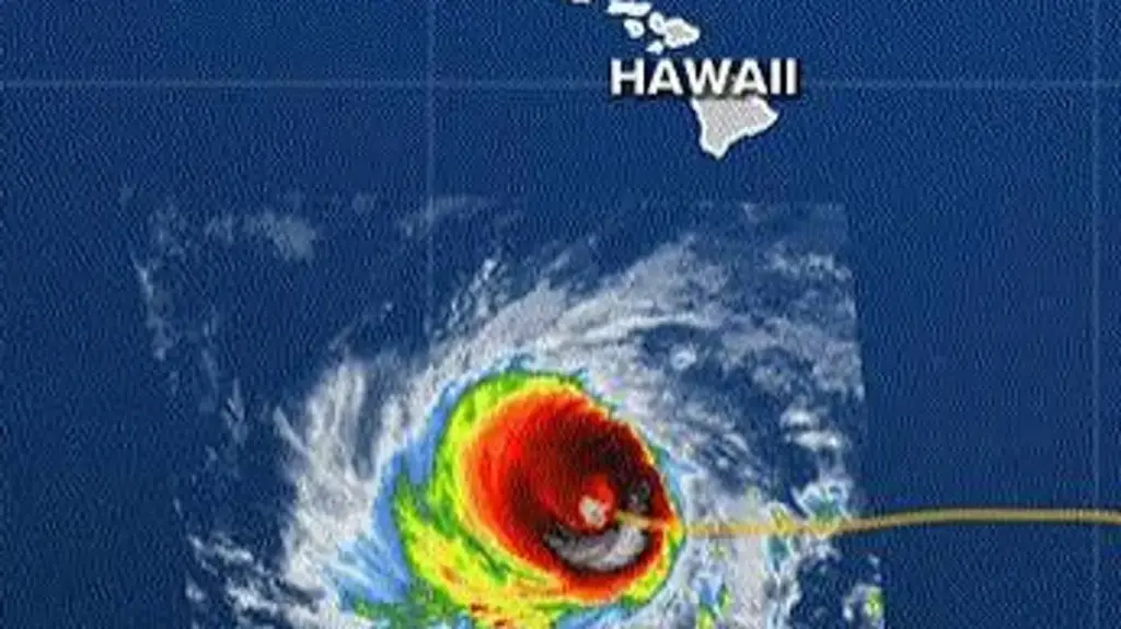
HONOLULU — Hawaii is bracing for severe weather impacts as Hurricane Lowell, a formidable Category 4 storm boasting maximum sustained winds of 150 mph, tracks northward toward the archipelago. While current meteorological forecasts indicate the storm’s core will likely pass just west of the main Hawaiian Islands rather than making a direct landfall, state officials are leaving nothing to chance.
Governor Josh Green has issued a comprehensive statewide emergency proclamation to mobilize resources, activate disaster response teams, and position emergency infrastructure across vulnerable communities. The developing situation has put residents on high alert, with emergency management agencies tracking not only Lowell, but also a secondary hurricane and an active tropical storm churning across the central Pacific basin.
Executive Overview
Hurricane Lowell remains a potent meteorological threat, currently positioned hundreds of miles south-southwest of Kauai and tracking on a trajectory that will bring it dangerously close to the islands of Kauaʻi and Niʻihau by Monday night. Although the storm has degraded slightly from its previous peak as a catastrophic Category 5 system, it continues to pack destructive winds, towering storm surges, and the potential for torrential downpours.
Governor Green’s emergency declaration covers multiple active Pacific systems—including Hurricane Lowell, Hurricane Karina, and Tropical Storm Marie—establishing an administrative framework that enables federal, state, and county agencies to rapidly allocate funds, deploy specialized equipment, and stand up the Hawaii National Guard if conditions deteriorate.
Although mandatory evacuations, curfews, and school closures have not yet been implemented, authorities are strongly urging residents and visitors in Kauai County to closely monitor forecasts and finalize their emergency preparations. The margin of error in Lowell’s track remains narrow; a shift of just 50 to 100 miles could drastically amplify the severity of local impacts, transforming a near-miss into a direct hazard.
Detailed Chronology of Events
The escalation of Hurricane Lowell from a distant open-ocean cyclone to a major direct threat to the Hawaiian Islands has unfolded rapidly over the past 48 hours.
Saturday, September 5, 2025
- 21:55 BST — Briefing Commences: Emergency monitoring desks open as the National Weather Service (NWS) and the Central Pacific Hurricane Center (CPHC) flag a significant shift in Hurricane Lowell’s forward speed and direction.
- 21:58 BST — State of Emergency Declared: Recognizing the immense destructive potential of the approaching system, Hawaii Governor Josh Green officially signs a statewide emergency proclamation, initiating coordinated preparedness protocols across all islands.
- 22:02 BST — Intensity Confirmed: Satellite data and reconnaissance flights confirm that Lowell is maintaining Category 4 status, with peak sustained winds holding near 150 mph alongside intense atmospheric gusts.
- 22:11 BST — The Northern Pivot: Forecasters observe Lowell initiating a critical structural turn. The storm, which had been moving on a west-northwest track, begins a gradual pivot toward the north and north-northeast, aligning on a collision course with the western approaches of the Hawaiian chain.
- 22:12 BST — Kauai County Focus: Emergency managers designate Kauai County—encompassing Kauaʻi, Niʻihau, Lehua, and Kaʻula—as the primary zone of concern. Preparatory warnings are broadcast, and authorities warn that coastal and tropical-storm watches will likely be issued shortly.
- 22:14 BST — El Niño Influence Discussed: Meteorologists release updated climate analysis, linking the storm’s unusual intensity and longevity to an exceptionally robust El Niño cycle currently active across the equatorial Pacific.
- 22:29 BST — The Track Margin of Error: Weather forecasters brief state officials on the precise trajectory, noting that the center of the storm is currently projected to pass 100 to 200 miles west of Kauai County. However, experts stress that minor wobbles in the vortex could bring severe weather much closer to populated shores.
- 22:31 BST — Pre-Positioning Assets: Governor Green confirms that high-water rescue vehicles, emergency generators, and medical stockpiles are already being staged on Kauai and Niʻihau to counter anticipated coastal flooding and washed-out roads.
- 22:33 BST — Comprehensive Pacific Threat Analysis: The official state update clarifies that while Lowell is the immediate priority, emergency resources are also keeping a cautious eye on Hurricane Karina (expected to pass harmlessly to the north) and the distant Tropical Storm Marie.
Supporting Context & Metrics
The meteorological mechanics driving Hurricane Lowell highlight a confluence of oceanic warmth and atmospheric conditions that have made the 2026 Pacific hurricane season remarkably volatile.
The El Niño Factor
Scientists and forecasters tracking the storm have pointed directly to a powerful El Niño event as the primary catalyst behind Lowell’s sustained strength. El Niño is characterized by anomalously warm ocean temperatures across the central and eastern tropical Pacific. These elevated sea-surface temperatures act as an inexhaustible thermal engine, pumping immense heat and moisture into passing tropical systems.
Furthermore, El Niño conditions often suppress vertical wind shear across large expanses of the Pacific basin. Wind shear—changes in wind speed and direction with height—typically acts to tear apart the vertical structure of developing cyclones. With minimal shear present, the intense thunderstorms surrounding Lowell’s eye have been able to remain organized, preserving its ferocious core structure even as it tracks into less favorable latitudes.

Key Storm Metrics
- Current Classification: Category 4 Hurricane
- Maximum Sustained Winds: 150 mph, with higher destructive gusts
- Distance to Land: Approximately 635 miles south-southwest of Lihue, Kauai (as of latest advisory)
- Projected Closest Approach: Monday evening / night
- Primary Threat Zones: Kauai County (Kauaʻi and Niʻihau)
- Pre-positioned Equipment: Six high-water rescue vehicles deployed to Kauai; multi-agency task forces on standby.
Official Statements and Administrative Responses
The Hawaii state government, working in lockstep with the Federal Emergency Management Agency (FEMA) and the National Weather Service, has adopted an aggressive posture to ensure public safety ahead of Monday’s anticipated onslaught.
In a televised address following his emergency declaration, Governor Josh Green emphasized that the state is treating the storm with the utmost gravity.
"We are taking Hurricane Lowell extremely seriously," Governor Green stated. "While current models show the center passing to our west, the sheer scale and intensity of this storm mean we cannot afford complacency. Our state, county, and federal partners have worked around the clock to position personnel, high-clearance vehicles, and life-saving equipment where they are needed most—particularly across Kauai County."
The emergency proclamation provides sweeping administrative powers, bypassing standard bureaucratic procurement bottlenecks to ensure swift acquisition of emergency supplies. It also places the Hawaii National Guard on heightened alert status, enabling rapid deployment for post-storm search-and-rescue operations, debris clearance, and infrastructural repair.
Local mayors have echoed the governor’s warnings, urging residents to secure outdoor property, clear drainage ditches, and ensure their emergency supply kits contain a minimum of two weeks’ worth of food, water, and essential medications. While no evacuations have been mandated, county officials have stressed that localized evacuation orders could be issued with little warning if flash flooding or storm surges exceed safety thresholds.
Future Outlook and Preparedness
As Hurricane Lowell continues its march northward, the coming 24 to 36 hours will be critical. Forecasters anticipate that the storm will begin a slow weakening trend as it encounters cooler ocean waters and gradually increasing vertical wind shear. However, meteorologists have issued strong warnings against underestimating the storm based solely on projected weakening trends.
Even a downgraded system packs immense kinetic energy capable of generating:
- Destructive Surf and Rip Currents: Massive ocean swells are forecast to batter southern and western shorelines, producing life-threatening rip currents and severe coastal erosion.
- Storm Surge and Coastal Inundation: Low-lying coastal communities, particularly on Kauai and Niʻihau, face the risk of inundation as wind-driven water piles up along the shorelines.
- Flash Flooding and Mudslides: Heavy, persistent rainfall bands wrapping around the northern perimeter of the storm could dump substantial precipitation over mountainous terrain, triggering rapid flash floods and dangerous hillside mudslides.
Residents across the Hawaiian archipelago are urged to stay tuned to local media outlets, monitor real-time updates from the Central Pacific Hurricane Center, and finalize their sheltering plans before conditions deteriorate on Monday.
Continuous updates, live radar tracking, and official advisories will be provided as Hurricane Lowell draws closer to the islands.