

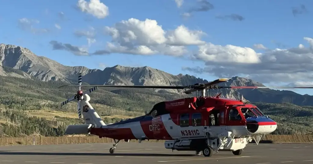
COLORADO — A comprehensive, multi-agency search and rescue operation is actively underway in the rugged backcountry of southwestern Colorado following the devastating crash of a single-engine aircraft into the forbidding northern face of Dolores Peak.
The incident, which occurred on Thursday, has mobilized local, state, and federal emergency response networks. Due to the treacherous, high-elevation topography of the crash site—situated roughly 15 miles southwest of the historic alpine town of Telluride—authorities have been forced to deploy specialized aerial insertion teams to reach the wreckage and assess the status of any potential survivors.
As federal aviation authorities prepare to launch a joint investigation into the root causes of the disaster, local officials have urged patience and caution as rescue personnel navigate extreme environmental hazards to secure the site.
Executive Overview
The unfolding aviation emergency began on Thursday afternoon when distress alerts and witness reports indicated that a light aircraft had gone down in a notoriously rugged sector of San Miguel County. The target of the intensive rescue effort is the northern escarpment of Dolores Peak, a towering geographic landmark rising over 13,000 feet above sea level within the San Juan Mountains range.
According to preliminary briefings released by the San Miguel Sheriff’s Office, the aircraft involved is a single-engine fixed-wing plane. The precise number of souls on board, the flight’s origin, and its ultimate destination remain unverified as emergency responders focus their immediate energies on life-saving operations and site containment.
The operation is defined by extreme logistical challenges. Dolores Peak and its surrounding terrain are characterized by sheer vertical cliffs, unstable scree slopes, dense alpine forests, and rapidly shifting weather patterns typical of early September in the Rocky Mountains. Because ground vehicles cannot navigate the verticality and dense wilderness surrounding the impact point, authorities have relied heavily on specialized rotary-wing aircraft to winch personnel, medical supplies, and extraction equipment directly onto the mountain slope.
While the aviation community and local residents anxiously await updates, the primary directive from unified command remains clear: locate survivors, administer emergency medical care, and secure the perimeter for subsequent federal investigators.
Detailed Chronology of Events
The timeline of the disaster and the subsequent emergency response highlights the rapid mobilization of regional assets in the face of daunting wilderness conditions.
Thursday Afternoon: The Impact and Initial Alerts
- Approx. Time of Impact: While exact radar tracking data has not yet been publicly released by the Federal Aviation Administration (FAA), initial emergency calls regarding a loud impact and a plume of smoke near Dolores Peak began reaching dispatchers on Thursday afternoon.
- Initial Assessment: The San Miguel Sheriff’s Office received immediate indications that a light, single-engine aircraft had struck the steep northern face of the mountain. Given the remote coordinates—approximately 15 miles southwest of Telluride—local dispatch immediately escalated the incident from a standard wilderness medical call to a major multi-agency aviation disaster response.
Thursday Evening: Mobilization and Aerial Insertion
- Unified Command Established: By late afternoon, the San Miguel Sheriff’s Office had formally coordinated a response framework involving multiple regional and federal entities.
- Deployment of Specialized Teams: Recognizing that standard ground transport would take hours—if not days—to scale the vertical terrain of Dolores Peak, commanders authorized the immediate use of high-altitude search and rescue helicopters.
- Insertion Phase: Search and rescue operatives, alongside specialized medical personnel, were systematically choppered into the immediate vicinity of the wreckage as daylight began to wane. The teams faced immediate obstacles, including steep angles, loose rock, and the physiological challenges of operating at high elevations where lower oxygen levels impair both human endurance and mechanical performance.
Friday Morning: Ongoing Operations
- Extended Search Radius: As of early Friday morning, rescue and recovery teams were actively working the perimeter of the crash site. The impact zone, situated on a severe incline, has required meticulous shoring up and rope-rigging to ensure the safety of the rescue workers.
- Status Updates: As of the latest official updates, authorities have not yet confirmed the condition of the occupants, keeping the investigation and rescue framework focused entirely on humanitarian efforts and stabilization of the site.
Supporting Context & Geographic Metrics
To fully understand the gravity and complexity of the ongoing rescue operation, one must examine the unforgiving geography of the crash location and the operational statistics surrounding single-engine mountain flying in the American West.
The Geography of Dolores Peak and the San Juan Mountains
Dolores Peak is a formidable geological formation. Standing at an elevation of roughly 13,290 feet (over 4,050 meters), it is part of the Lizard Head Wilderness area within the San Juan Mountains.

- Elevation & Environment: The high altitude introduces severe environmental hazards, including acute mountain sickness (hypoxia) for ground crews, freezing nighttime temperatures, and sudden micro-meteorological shifts that can ground rescue helicopters with little warning.
- Inaccessibility: The northern face of the peak—where the aircraft impacted—features sheer rock walls and steep snow/ice chutes that make foot travel exceptionally perilous. The nearest population center, Telluride, sits in a box canyon surrounded by similarly towering peaks, serving as the logistical staging ground for mountain rescue operations in the region.
The Multi-Agency Emergency Infrastructure
A disaster of this magnitude in a remote wilderness requires seamless coordination across a diverse array of public safety organizations:
- San Miguel Sheriff’s Office: Serving as the lead investigative and operational agency with jurisdiction over the backcountry terrain.
- San Miguel Search and Rescue (SMSR): A dedicated cadre of highly trained mountaineers, trackers, and medical technicians specializing in high-angle rope rescue and wilderness survival.
- Bureau of Land Management (BLM): Providing federal jurisdictional support, land-use coordination, and logistical assets for the public lands surrounding the peak.
- Telluride Fire Protection District: Bringing advanced life support (ALS) medical capabilities, structural and wildland firefighting expertise, and specialized trauma response personnel to the staging area.
Official Statements and Media Briefings
In the wake of the tragedy, local authorities have maintained a transparent yet cautious posture as they manage the unfolding rescue operation.
In an official statement released by the San Miguel Sheriff’s Office, representatives detailed the core parameters of the response:
"A single-engine aircraft has crashed on the north side of Dolores Peak approximately 15 miles SW of Telluride. Teams are being inserted via helicopters to determine if there are survivors."
Law enforcement officials have emphasized that speculation regarding the cause of the crash, the identities of those on board, or the survival rates is entirely premature. The focus of the unified command remains strictly localized to the mountain face.
Furthermore, aviation safety advocates have noted that mountain flying in the Rocky Mountains presents unique aerodynamic challenges. Rapidly changing barometric pressures, downdrafts, density altitude issues caused by warm summer and early autumn temperatures, and sudden orographic lift can overwhelm even experienced pilots flying single-engine aircraft. However, investigators have stressed that it is far too early to attribute environmental factors or mechanical failure to Thursday’s crash.
Future Outlook: Investigation and Recovery
As the immediate search and rescue operation pushes through its critical window, the operational focus will inevitably shift toward investigation, wreckage recovery, and site remediation.
The Federal Investigation
Once search and rescue operatives have completed their primary directive—securing human life and providing medical triage—federal oversight will transition to the National Transportation Safety Board (NTSB) and the Federal Aviation Administration (FAA).
- Wreckage Documentation: NTSB investigators will be winched down to Dolores Peak to map the debris field, document flight control settings, examine engine components, and recover any onboard avionics or flight logs.
- Environmental Hurdles: Due to the extreme altitude and remote location of the debris on the north side of the mountain, extracting the heavier components of the single-engine aircraft may require heavy-lift commercial helicopters and days of painstaking technical rigging.
Community Impact and Support
The tight-knit community of Telluride and the broader San Miguel County populace have rallied around the emergency response teams, providing logistical support at staging areas and offering solidarity for the families affected by the tragedy. Local authorities have established temporary air-space restrictions (Temporary Flight Restrictions, or TFRs) over Dolores Peak to ensure that private drones and media aircraft do not interfere with the hazardous low-level helicopter insertions required by the rescue crews.
As updates become available from the unified command post, further details regarding the investigation and the status of the operation will be released to the public. For now, the eyes of the aviation and mountain rescue communities remain fixed on the steep, unforgiving slopes of Dolores Peak.